WALDORF, Md. — The most productive tributary of the Potomac River bass fishery is at risk. And in a disturbing turn, those who promote Mattawoman Creek as a destination for anglers favor the development that could trigger its destruction.
"While the county [Charles] promotes bass tournaments and touts Mattawoman, its policies are aimed in the direction opposite protecting the resource," said Jim Long of the Mattawoman Watershed Society.
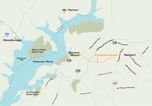
Indeed, sources say county commissioners are among those pushing the hardest for an extension of the four-lane Cross County Connector that would cut across the heart of the creek's 94-square-mile watershed. The highway would connect the county's urban center, Waldorf, to the tiny town of Bryans Road and, in the process, induce waves of development outside state-sanctioned growth areas and across thousands of acres of forests and wetlands.
In a document provided to BASS Times, Charles County defended the project by pointing out that it follows recommendations in three consecutive Comprehensive Master Plans (1990, 1997 and 2006).
Additionally, it said, "if the road infrastructure is not improved to support planned growth in this part of the county, developers will build their own access roads. … This would lead to an uncoordinated and fragmented patchwork of road improvements, leaving inefficiencies, substandard safety conditions and long-term environmental impacts, instead of an effectively managed single and cohesive linear project, a designed and engineered connector highway that meets the highest environmental standards."
Opponents are not swayed by such assurances.
"We are adamantly opposed," said Roger Trageser, president of the Maryland B.A.S.S. Federation Nation. "No one is opposed to progress, but we are opposed to where they want to put this, where it would run the risk of destroying the top spawning area."
On the Virginia side of the Potomac, Joan Blankenship of the Virginia B.A.S.S. Federation Nation added, "We have not taken an individual position on this development as it is in Maryland and out of our area. However, as members of the conservation network, we are greatly concerned about the threat to Mattawoman Creek, as it does empty into the Potomac River and our members do fish in that area."
And not only Mattawoman and the Potomac are threatened. The highway and associated development would provide yet one more blow to the health of the entire Chesapeake Bay ecosystem.
In a 2005 report to county commissioners, the Maryland Department of Natural Resources (DNR) said, "Mattawoman is the best, most productive tributary in the Bay." It added that the creek possesses one of the healthiest aquatic food-webs baywide, with twice the density of largemouth bass as in the Potomac and three to 10 times more than Piscataway (depending on time of year).
"Mattawoman represents as near as ideal conditions as can be found in the northern Chesapeake Bay, perhaps unattainable in the other systems, and should be protected from overdevelopment," the agency continued.
Well-known guide Ken Penrod added, "Mattawoman Creek is the most productive tributary of all the fine Potomac River branches."
And yet, right now, Mattawoman is on the brink of losing that productivity, according to scientists. As the last tidal freshwater estuary beyond the urban sprawl of Washington, D.C., an estimated 8.5 percent of its watershed is the "impervious cover" of asphalt, concrete and associated development.
"Studies suggest that about 10 percent impervious cover constitutes a threshold for significant impacts to aquatic resources," reported the U.S. Army Corps of Engineers. "It is generally recognized that if impervious cover exceeds 15 percent, impacts can be severe."
Those impacts include increased flooding, erosion and runoff pollution, as well as water quality reduced by heated water from paved surfaces.
"People want to live in areas with good, clean water," said Richard Eskin, director of the science services administration for the Maryland Department of the Environment (MDE). "It's our mission, our goal, to protect high-quality water."
Both the Corps and the MDE must approve permits before the connector can be built across Charles County. And MDE has made it clear to the county that those permits won't come quickly or easily, much to the delight of anglers and others who oppose the highway.
In response, commissioners apparently are considering legal remedies, according to the Independent newspaper. Following an executive session in which legal options were discussed, F. Wayne Cooper, commission president, told the newspaper: "The plans to move forward are at a standstill, and I do mean standstill. The county has spent more than $650,000 to analyze the impact of the cross-county connector.
"We're in a state of paralysis by analysis. We have been jerked around by the U.S. Army Corps of Engineers and the Maryland Department of the Environment."
Opponents, however, want less-damaging alternatives to be considered, including better utilization of existing four-lane highways and investing in modern light rail and transit-oriented development in Waldorf. Jim Long of the Mattawoman Watershed Society is asking anglers to write Maryland Gov. Martin O'Malley, asking that he direct MDE to deny permits.
Should permits be approved, however, defenders of the creek likely will demand that the Corps prepare an environmental impact statement in which the full economic, social and environmental cost of the connector would be analyzed, according to American Rivers, which named the Mattawoman as one America's most endangered rivers in 2009.
Potomac access at risk
Upstream from where development threatens Mattawoman Creek, anglers and fishing guides worry that the National Park Service (NPS) will impose regulations that severely restrict access to some of the Potomac's best bass waters.
"In effect, operation of outboards would be prohibited," said guide Steve Chaconas. "And if the boundaries are as far as they indicate, it might be too much trouble to get close to where the fish are [using a trolling motor]. It could eliminate fishing in a huge area, including one of the most historic fishing spots on this end of the river, Hogg Island."
NPS asserts that it owns the "submerged lands" stretching out from Dyke Marsh Wildlife Preserve on the Virginia side. Much of the area was marsh at one time. But erosion and dredging turned a large portion into open water.
Park Superintendent Dottie Marshall, however, said she plans to initiate a formal rulemaking process, with public input beginning this fall.
"Given the controversy, we thought it best to go through this process," she said. Until that is completed, the NPS intends to ban motorboat operation in waters of the Dyke Marsh Wildlife Preserve without an official permit, which is issued only for research, maintenance or other official government purposes.
Marshall added that clarification probably will be added to ensure that anglers can access these waters via trolling motors only.
Chaconas believes the ban is prompted by pressure from groups that want to keep hunters and fishermen out of the area. He added that establishing a no-wake zone in the NPS area is a sensible solution that anglers and hunters could live with.