
THURSDAY:
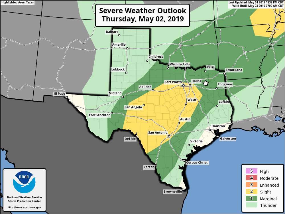
Unfortunately, it looks like this year’s Texas Fest will be getting off to a stormy start. The Storm Prediction Center (as of 10:30 pm Wednesday night) has the Lake Fork area in a Marginal Risk (level 1 of 5) for severe storms during all of Thursday. The high-resolution forecast models are showing for the possibility of at least one round of storms to move through the area close to the midday hour that will have the potential for heavy rain, dangerous cloud-to-ground lightning, isolated damaging wind gusts up to 60 MPH, large hail, and an isolated tornado. There is the likelihood of scattered showers and storms throughout the day, but the main risk for stronger storms will be from 11:00 am through the end of the fishing day. Not much sunshine can be expected and winds will be out of the south at 6-12 MPH throughout the day. Temperatures will start off in the upper 60s at 7:00 am and top out in the upper 70s for the daytime high. Dewpoints will be in the upper 60s all day. Rain chances will be around 60% and totals could approach 0.75 inches. Please stay weather aware. If you can hear thunder, you are close enough to the parent thunderstorm to be struck by lightning.
FRIDAY:
At this point, Friday has the possibility of being stormy at times as well. rain chances will be back right up in the 60% range throughout the day as scattered to numerous showers and thunderstorms are likely. It won’t be an all-day rain but expect rain at any time. Skies will be cloudy with afternoon highs topping out in the mid-70s after starting off in the mid-60s at 7:00 am. Winds will be out of the south at 5-10 MPH. The good news is that severe storms are not expected as of now, but the Storm Prediction Center has a Marginal Risk up for locations not that far to the west of the event. Dewpoints will be in the upper 60s.
SATURDAY:
The good news is that the weekend is trending much drier with only a very small chance of an isolated shower or thunderstorm during the morning hours on Saturday. Clouds will be decreasing throughout the day and dewpoints will be down in the lower 60s. Temperatures will start off in the lower 60s at 7:00 am and warm up into the upper 70s for the daytime high. Winds will be out of the north-northwest at 4-8 MPH. Chance of rain will be around 25% for the morning hours, then totally dissipating after.
SUNDAY:
A good bit of sunshine and dry weather can be expected on Sunday as skies will be mostly sunny throughout the day. Temperatures will start off in the upper 50s or right at 60 degrees and will warm into the upper 70s to right at 80 degrees for the daytime high. Winds will be out of the east at 1-4 MPH to start but will shift to out of the south-southeast by early afternoon at 2-7 MPH. Dewpoints will creep back up into the mid-60s by the early afternoon hours.
MONDAY:
Another nice day on Monday with dry and warm conditions. Skies will start off mostly clear but clouds will be on the increase throughout the day, ending up with partly cloudy skies by weigh-in. Temperatures will start off in the upper 60s at 7:00 am and will warm into the lower 80s for the daytime high. Winds will be out of the southeast at 5-10 MPH. Dewpoints will be in the upper 60s.