
When I began my career, lake maps were pretty basic. In most cases, they offered a simple overview of a lake or river with little or no detail below the surface. Of those that did provide subsurface features, the details were usually vague and inaccurate.
There were exceptions, however. National Oceanic & Atmospheric Administration (NOAA) charts did provide good detail of both shoreline and subsurface features. But NOAA charts were expensive and not readily available. Worse, they only cover inland waterways connecting to saltwater.
My first charts
The first charts I remember were hand-me-downs from my grandfather — lake maps by Rube Allyn, the former publisher of fishing periodicals who founded the Florida Outdoor Writers Association. His maps were very basic, but they did aid somewhat in navigation.
Later, I discovered mapping created by Southern Guide, Hooksetter, Atlantic Mapping and Lakes Illustrated (the ones endorsed by Tom Mann). At the time, they were considered “advanced” cartography. Although not truly accurate, they did approximate the location of submerged creekbeds, ditches, humps and many other unique subsurface features. And some were waterproof, which was a major advancement back then.
About the time I learned of NOAA charts, I also discovered aerial plat maps … particularly the ones for reservoirs that show what the terrain looked like before they were impounded. Those were a big help.
To better define a specific body of water, I would cross-reference the details of these various maps. I believed the more input I could gather, the better. Of course, applying that information was a little tricky, and the info didn’t always pan out. You could say it was catch as catch can.
Technical tributes
Nowadays, lake maps are incredibly accurate and readily available. And most serious anglers prefer electronic mapping over paper.
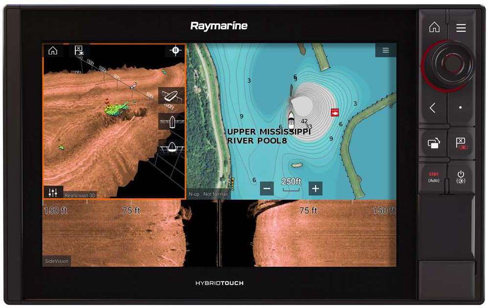
Map “cards” or “chips,” as they are referred to, aren’t cheap but they are handy and compatible with most GPS units. Among the leading brands are Navionics, LakeMaster and Fishing Hot Spots — companies whose services are constantly adapting to ever-changing technology. In fact, now there is interactive mapping — shared cartography with companies like Navionics and Fishidy.
Navionics’ SonarChart Live allows its users to create personal bathymetry maps and display them in real time while navigating any body of water. The feature is enabled by connecting the sonar to a mobile device installed with the Navionics Boating App. All you need is their Navionics+, Platinum+ or HotMaps Platinum card, a compatible GPS capable of logging data to the card, and a computer to up- and download that information. Even cooler, there’s almost no limit to the amount of mapping you can do once you sign up. It’s just a matter of gathering the data, then uploading it to their website. They’ll do the rest.
Another benefit of the SonarChart program is shared data. As other users submit their logs, that information is added to existing data — without any risk of sharing prized weighpoints. So, as time passes, the charts become more and more defined. It’s a great concept, and one that benefits all involved.
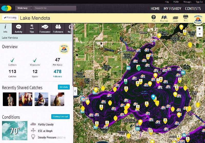
Similarly, Fishidy offers communal mapping. Theirs, however, is different in the sense that it offers an “activity log” where you can store weighpoints and other info, such as water temp, depth, wind speed and direction, your most productive lures and patterns — even photos of fish caught in specific locations. You can choose to keep your data private or share it with others and benefit from their data. The site provides aerial satellite imagery of lakes and rivers throughout the country, blending them with licensed Hot Spots bottom contours where available.
Lake map summary
So whether you like “social” mapping or prefer a more individual approach, the bottom line is that there are really good maps out there. And if you have a compatible GPS capable of loading these maps, you’re eons ahead of where I began.
Take full advantage of this mapping data and learn to use it effectively. By familiarizing yourself with unique features of the lakes or rivers you plan to fish, you’ll shorten the time to finding productive water … guaranteed!