
The average high for Scottsboro, Alabama for this time of year is 88 degrees, while the average low is around 65 degrees. The weather will be a little warmer than that as a ridge of high pressure will build over the southeastern United States that will pump warm and humid air up from the Gulf of Mexico. Unfortunately, that means that there will be a chance of scattered showers and thunderstorms each day through the weekend and into the start of next week. Here are the details for each day of the tournament.
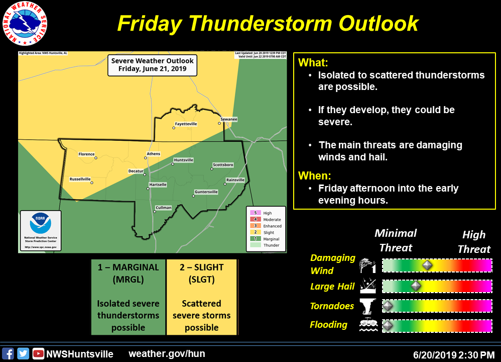
FRIDAY
The day will start off mainly clear with plenty of sunshine and temperatures in the mid-60s. Temperatures will increase rather quickly through the morning and early afternoon hours, topping off around 90 degrees at the weigh-in. Clouds will build during the day but will only be partly cloudy by 2:00 pm. There is a chance of showers and thunderstorms, but those look to come after the fishing day is complete. Any storms that develop during the late afternoon hours and into the evening hours could be strong to severe. Winds will be calm at the start but will eventually be out of the southwest at 1-5 MPH. Dewpoints will be in the lower 70s with heat index values running about 5 degrees above actual temperature.
SATURDAY
Skies will be partly to mostly cloudy throughout the day and there will be a small chance of a few scattered showers and thunderstorms. Rain chances at this point only look to be around 30%. Dewpoints throughout the day will be in the mid-70s, making those heat index values about 5-8 degrees warmer than the actual temperature. We’ll start off in the lower 70s at launch and top out around 90 degrees for the afternoon high. Winds will be out of the southwest at 1-5 MPH.
SUNDAY
Nearly the same story as Saturday… partly cloudy skies throughout the day with a small chance of an afternoon scattered shower or thunderstorm. Dewpoints will be a little lower, but still in the lower 70s. Temperatures will start off around 70 degrees and will top out in the lower 90s. Winds will once again be out of the southwest at 1-5 MPH. The chance of rain will top out around 30%.
MONDAY
A surface front will move into the area and will bring an increased risk of showers and thunderstorms throughout the day. There looks to be some chance of a few stronger to severe storms as there will be an increase in bulk shear levels. Temperatures will be cooler during the afternoon hours, topping out in the upper 80s. It will continue to be a muggy day with dewpoints in the lower 70s. Skies will start off partly cloudy with clouds increasing throughout the day. Temperatures at launch will be around 70 degrees. Chance of rain throughout the day is currently at 50%.
LUNAR STATUS
The moon will be in the Waning Gibbous stage throughout the event weekend, as the full moon occurred on June 17th. Therefore, the illumination of the moon surface will be decreasing. Here are moonrise and moonset times:
Friday: 9:45 pm rise / 10:22 am set
Saturday: 10:39 pm rise / 10:55 am set
Sunday: 11:34 pm rise / 11:26 am set
Monday: 12:30 am rise / 11:58 am set
IT’S SUMMERTIME
The Summer Solstice takes place on Friday morning at 10:54 am CT. This will be the day that features the longest amount of sunlight at 14 hours, 29 minutes. Sunrise will be at 5:31 am and will set at 8:00 pm.