Today’s electronics are highly sophisticated devices with capabilities that anglers couldn’t even have dreamed of just a few short years ago. One of those capabilities has to do with creating your own angling maps —detailed guides that will help you catch fish for a long time to come.
Getting the most out of your electronics isn’t necessarily easy. Time with the units and their user guides on and off the water will help, but I’ve discovered that these five tips get me a lot more bang for my buck when it comes to mapping.
1. Update your mapping cards
I use Navionics HotMaps Platinum and Navionics + chips. The Platinum chips are pre-loaded with lakes in a certain region, while Navionics + is a card that covers all of the U.S. and Canada, but you download the areas you are going to be fishing before you go.
Both chips are great out of the package, but whatever chip you have you’re missing out if you don’t update them regularly. Navionics is constantly updating their maps (almost 20,000 updates a week on average), so by updating the chips I get details that may be drastically different from someone who doesn’t update.
2. Use your phone or tablet on the water
I’ve learned that mobile devices such as smart phones or tablets can be great tools to help you break down a body of water more efficiently. Paper maps are great, but they are not as accurate as far as a lake’s topography is concerned and they lack definition.
I still carry paper maps because they’re great for taking notes and they sometimes have information the new mapping technology doesn’t have yet, but I don’t rely on them as much as I used to.
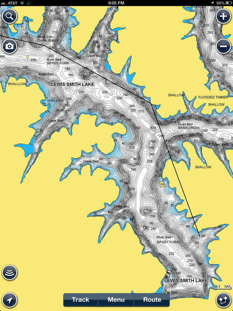
Currently I keep my iPad in a waterproof case and position it next to me while I fish. The great thing about an iPad is that you get a large visual of both satellite imagery and a lake’s depth contours with the Navionics Mobile App. One feature I use a lot to break down a lake is the shaded depth feature that allows you to shade a certain depth zone. Also, I can keep up with weather trends and do internet research while I’m on the water. The possibilities are endless using mobile devices while you fish.
3. Do your own mapping
One cool thing I’ve learned is that Navionics makes it easy for anglers to record their own sonar recordings and upload them onto their website to fine-tune maps in certain regions.
Last year I wanted to go fish the Alabama River near Montgomery, but there were few decent maps for the area. Just so I’d have maps for the next trip, I spent a couple days graphing key areas I liked, uploaded them onto the Navionics website and within a couple of weeks I was able to access the updated “SonarCharts” and use it to my advantage.

Though the Alabama River was a massive undertaking, you can make great maps for your lake simply by putting a blank SD card in your sonar/GPS unit and recording tracks. You’ll be amazed at the before and after results.
4. Eliminating water
One of the best ways to use your mapping technology and your GPS unit to eliminate unproductive is by making a small adjustment to highlight only the productive depth zones. In your GPS or on your mobile mapping device, you can actually adjust the depth range that is shaded. Now if I know that the best fishing is going to be in a certain depth range —say 20 feet or less —then I can adjust the depth range to that and the map will show me where to find those depth zones. I can eliminate the rest, making the lake much more manageable.
5. Cross referencing
Though Navionics is an excellent tool, there is no product or resource out there that has it all. If you can, it’s best to use several different sources, such as paper maps and satellite imagery to find those sleeper spots, allowing you to maximize your research.
Some paper maps mark old foundations better than any other mapping source, and satellite images can show you where vegetation is prevalent, where clear water may be located or even areas that no other mapping source has documented. Use them all to your advantage.