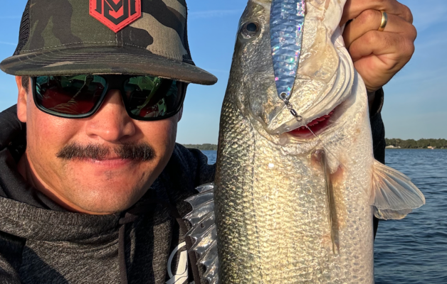
When Wayne Olsen started fishing Lake Anna, a 9,600-acre reservoir in north-central Virginia, he focused most of his efforts in the stained, upper reaches of the reservoir. But with the growth of Northern Virginia and Richmond — both a short drive from Anna — fishing pressure, along with the desire to explore his new home lake, pushed the full-time guide to the clearer water at the lower end of the reservoir. That was when most bass anglers avoided clear water, and Olsen figured he could have much of that region of the lake to himself.
Now, nearly 30 years later, he knows just about every inch of the 200 miles of shoreline, and fishing pressure and pleasure boat traffic have increased exponentially. Olsen still searches for new places to put his clients on bass — places that don’t get pounded by hordes of other anglers. Other spots on his “milk run” simply go cold, a common malady on any lake. It’s a scenario repeated on water throughout the country. Time and time again, anglers are forced to search for new water on lakes they know well. Yet in many cases, it turns into a positive experience.
Of course, it’s not just fishing pressure that can make you search for new places. Tim Horton, who started his professional fishing career as a guide on Alabama’s Pickwick Reservoir, recalls a day when he was fishing alone on the 45,000-acre lake on the Fourth of July. Pleasure boat traffic was heavy, and the constant rocking from wakes made fishing unbearable, so he pulled up his electric motor and headed for quieter waters.
“I went way off into the back of a creek and found a place that was loaded with largemouth. They were back there because of the cooler water coming in from the creek,” he recalls. “Had it not been for all that boat traffic, I would have never gone exploring, at least not 10 miles up a creek. I just wanted to find some quieter water.”
It helped that mudflats kept all but the most dedicated bass fishermen from finding this spot, and Horton admits that virtually no visible or shallow secrets exist on such heavily fished lakes as Pickwick. Somebody knows about it. But the excitement of finding something new and actually catching bass there makes it thrilling, nonetheless.
Back off
Professional angler Rick Lillegard guides on his home water, 44,000-acre Lake Winnipesaukee, when he isn’t on the road or fishing another tournament. After 15 years of probing the best spots, he’s become intimately familiar with every log, rockpile and spawning flat on the lake. If it holds bass in shallow water, the odds are pretty good Lillegard has dropped a lure next to it.
“As a guide, you really have to go back to those spots that produce, because you have to put your clients on fish. But when I fish tournaments, I often have to find new places, because there’s a good chance somebody else will be working the water I want to fish,” he says. “To find new water that either doesn’t get fished much or that has never been fished, I’m going to back off and work deeper places that aren’t visible from a boat. These are places that have to be found with a map and a good depthfinder. A lot of anglers either don’t know how to find offshore cover, or they simply don’t bother looking for it.”
That’s when Lillegard spends far less time actually fishing than simply idling across open water with one eye fixed on the depthfinder and the other on a topo map across his lap.
Horton used such a tactic to claim first place in the 1999 Bassmaster Top 150 held on the Potomac River. Although it’s not his home water by any stretch, he knows the river as well as do many locals. And during this particular tournament, he knew that in order to place high in the standings, he’d have to find somewhere that wasn’t going to get fished hard — a universal complaint during tournaments on this tidal river. Horton found victory on a small rockpile in the middle of a huge, shallow, featureless bay at the mouth of the Occoquan River.
“I just spent much of the practice period running around and looking for something different on my depthfinder. I liked the general area of that bay because there were lots of birds around, and that told me there was probably a lot of bait. If you can find bait, there are usually bass nearby,” he says.
But where? Horton admits that blind luck took his boat directly over a slight change in the bottom, and when his depthfinder showed a rise from 5 feet to 3 feet, he threw out a marker buoy and started fishing — and catching one quality largemouth after another.
The fear factor
Finding new water is perhaps one of the most daunting tasks anglers face. Aside from the obvious concept of abandoning the familiar for the unknown, searching for new places to fish can be a hit or miss proposition. Horton figures that one in 20 new spots actually produces fish, but he makes it a point to scout out new water regularly, despite the odds.
“When I was guiding, I’d spend an hour every day searching for new places, particularly if we already had a good day. When I’d go out by myself, I would often do nothing but search for new water. You just have to force yourself to do it,” he says.
Deciding to find new water, even if you aren’t forced to do so by crowded conditions or harsh weather, comes down to a desire to do so and then stick to a plan. As Lillegard says, you may know a lot of good spots, but you certainly don’t know all of them; and only by keeping an open mind will you learn some more.
“You have to make yourself go somewhere you’ve never been before, or go back to a spot that you may have tried once or twice and gave up on because you didn’t catch any fish,” he says.
Olsen and Horton agree. Just because a spot that looks good doesn’t produce fish on the first, second or even third try doesn’t mean it won’t hold bass. Horton says seasonal patterns have as much to do with a bass’ desire to use a specific spot as anything, so he’ll come back to these kinds of areas throughout the year and fish them.
“There have been some areas that didn’t produce for an entire year, and then I came back and there were fish on them. These spots had all the right ingredients, so I figured that sooner or later, there would have to be some bass on them,” he adds.
As with any bass fishing, it’s vital to keep a high level of confidence, which is perhaps the most challenging aspect of working new water. Horton admits that he will lose focus fairly quickly if he doesn’t see bait or bass on his Lowrance X-15, but if he does detect the presence of life, he’ll fish longer and harder.
Work it well
So how do you fish a spot for the first time? Obviously, seasonal patterns should be considered, but Horton typically starts with a fast moving bait to see if he can pick off a couple of bass right off the bat. Crankbaits are one of his top choices for deeper cover, but if they don’t produce anything, he’ll simply work his way to slower lures.
Olsen’s favorite tactic for fishing a new spot, particularly a deeper one, is to drag a Carolina rigged lizard or finesse bait across the bottom. Lillegard uses the same tactic, adding that Carolina rigs are perhaps the most efficient method of working deep offshore structure. It’s a good all-season tactic.
“I’ll work a spot real hard from a variety of angles, and I’ll come back a couple of times during a day, even if I don’t catch anything. The fish just might not be in the mood to eat the first time or two,” says Olsen.
The up side of drawdowns
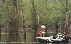
One of the best times to find structure and cover that you never knew existed is when a lake is below its normal level. Whether it’s due to maintenance, seasonal fluctuations or an unusually dry year, lake pools rise and fall drastically — exposing all manner of great spots. Olsen’s home lake dropped 3 feet — the lowest he’s seen in nearly 30 years. Although a 3-foot drop may not seem significant, he’s found countless features he never knew existed — features that will surely hold bass when the water comes back up.
“I found some places that I knew had a few stumps, but I had no idea exactly how many were there until this low water. I got a good look at where the stumps were in relation to the normal bank, where the better-looking ones were and what the bottom looked like around them. I’m excited about fishing them,” he says. He also found isolated boulders, which, along with stumpbeds, aren’t shown on lake maps — not even the most detailed ones.
The problem with drawdowns, of course, is simply getting a boat into the water. During severe conditions, boat ramps go dry, and actually getting onto the lake is the most difficult part of the process. When that happens, it’s time to lace up your boots and go for a hike or borrow a canoe or small johnboat and carry it down to the water.
“Do whatever it takes to get on the water to have a look around during low water conditions. You may not be able to cover the entire lake without your bass boat, but at least you’ll learn something, even if it’s a single stump or rockpile you didn’t know existed,” adds Olsen.
And once you find something you never knew was there, mark it on a map, or even take a photograph, making sure to include landmarks on the shore to help you find it in the future. By shooting a picture, there will be no doubt about how to best approach a particular piece of submerged cover.
The search for new water on your home lake doesn’t have to be a last-ditch effort, something you do only because you are forced to. Finding new spots can not only put you on more bass, it can turn into another lesson — a learning experience that teaches you to become a better bass angler no matter where you fish.
A view from above
Although quality maps show old roadbeds, bridges and other structure now under water, Lake Anna, Va., guide Wayne Olsen occasionally refers back to aerial photos to find new places on his home lake. These photos were taken before the lake was filled, often just weeks or months before the floodgates were closed and the water started rising.
“I’ll use the aerial photos in conjunction with the topo map, because the topo maps are often inaccurate when it comes to specific details. By having both, I can match them up when I’m on the water. I’ll use the map and photo to get me close, and then my depthfinder to find the exact spot I’m looking for,” he says.
Aerial photos are available from a number of government agencies, including the United States Geological Survey (USGS), the U.S. Army Corps of Engineers and even local government offices. The USGS has a searchable Web site of aerial photos, many of which were taken before reservoirs were filled. Visit http://edc.usgs.gov/. The “Survey” link takes you to older photos. For more information, call the USGS office at 605-594-6151.